All practical examples in this book rely on OpenSource software and freely available data sets. Quantum GIS (QGIS) is introduced for basic GIS data handling, and in-depth spatial analytics and statistics are conducted with the software package R.
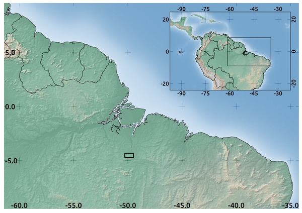
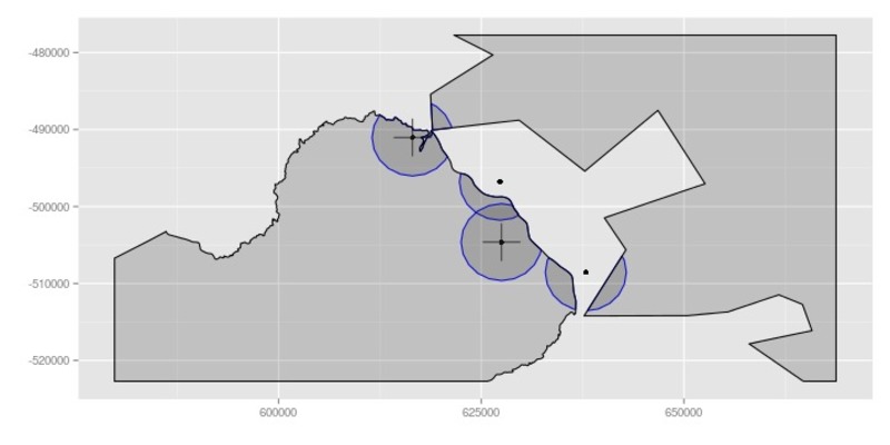
Study area in Brazil used in the book.
Readers will learn how to apply remote sensing within ecological research projects, how to approach spatial data sampling and how to interpret remote sensing derived products. The authors discuss a wide range of statistical analyses with regard to satellite data as well as specialised topics such as time-series analysis. Extended scripts on how to create professional looking maps and graphics are also provided.
This book is a valuable resource for students and scientists in the fields of conservation and ecology interested in learning how to get started in applying remote sensing in ecological research and conservation planning.
Content of the book:
Foreword
Woody Turner
Preface
Martin Wegmann, Benjamin Leutner and Stefan Dech
Introduction
Nathalie Pettorelli
Spatial Data and Software
Benjamin Leutner, Ned Horning, Duccio Rocchini and Martin Wegmann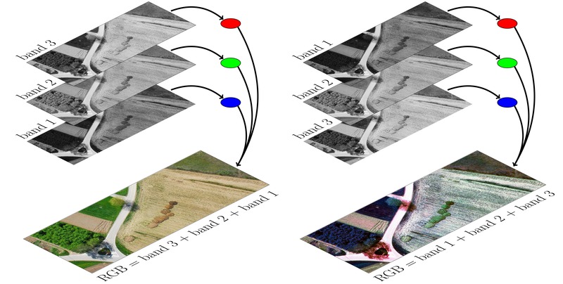
Chapter 1 introduces spatial data and software: what does open-source mean? It discusses open vs free software and licensing, gives an overview and comparison of QGIS and R, as well as alternatives including GRASS, SAGA, Proj.4, GDAL/OGR and initiatives such as OSGeo.
Introduction to Remote Sensing and GIS
Martin Wegmann and Benjamin Leutner
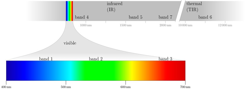
Chapter 2 introduces remote sensing: RS systems (optical, active, passive), space-borne and air-borne; data properties: spatial, spectral, radiometric and temporal resolution. This chapter also discusses issues in remote sensing such as the types of resolutions and requirement trade-offs.
Where to Obtain Spatial Data?
Martin Wegmann and Benjamin Leutner
Chapter 3 discusses where to get spatial data: which data sources are currently available? What are the prospects? Where can you get free data? When/why purchase data and which? It introduces Vector data and Raster data and where to get them.
Spatial Data Analysis for Ecologists: First Steps
Benjamin Leutner, Martin Wegmann, Mirjana Bevanda and Ned Horning
 Chapter 4 is about the first steps in approaching spatial data analysis for ecologists: defining the aim, first assessment of available data, creating an archive, options and challenges, and defining ecological requirements: special, spectral, temporal resolution, extent and projections.
Pre-Processing Remote Sensing Data
Benjamin Leutner and Martin Wegmann
Chapter 5 explains the necessary initial preprocessing steps: projections and transformations, data conversion, data formats, corrections, stretching methods, spatial masking and others.
Field Data for Remote Sensing Data Analysis
Christian Wohlfart, Mirjana Bevanda, Ned Horning, Benjamin Leutner
and Martin Wegmann
 Chapter 6 is about how to sample field data for remote sensing data analysis: what to measure and why measure it? It discusses the importance of efficient sampling strategies, GPS handling, remote sensing and in-situ data measurements, land cover field data sampling approaches, further relevant measurements, collecting on-screen training data from GoogleEarth/Bing or aerial imagery etc. using QGIS, and importing/exporting to analysis software.
From Spectral to Ecological Information
Duccio Rocchini, Benjamin Leutner and Martin Wegmann
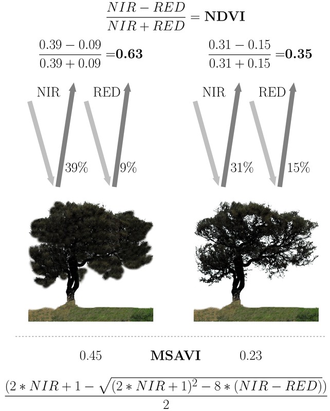
Chapter 7 introduces approaches to extract spectral information and discusses principles and comparisons. Well-established spectral indices such as the NDVI will be introduced and, additionally, further relevant indices such as the MSAVI, EVI and transformation approaches will be covered.
Land Cover or Image Classification Approaches
Ned Horning, Benjamin Leutner and Martin Wegmann
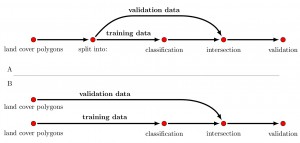
Chapter 8 explains how to conduct image classification: classification principles, classification types (un-supervised and supervised approaches), and usage in real-world examples: land cover vs. land use classification will be discussed, as well as practical examples of collecting training samples, generating a landcover classification using R, evaluating a land cover classification (accuracy assessment, statistics) and accuracy assessment of classification results.
Land Cover Change or Change Detection
Ned Horning, Benjamin Leutner and Martin Wegmann
Chapter 9 discusses land cover change (change detection) and various change detection methods that can be accomplished with available open source tools. Land cover change maps will be created using methods in R and you will be shown how to map the results.
Continuous Land Cover Information
Ned Horning, Benjamin Leutner, Mirjana Bevanda and Martin Wegmann
Chapter 10 describes continuous land cover information: generating a continuous vegetation map; discussing its disadvantages and advantages and potential errors.
Time Series Analysis
Jan Verbesselt, Fabian Loew, Christian Wohlfart and Martin Wegmann
Chapter 11 goes into depth on time-series analysis. In this chapter time-series data such as MODIS will be used to derive phenological metrics, analyse temporal breakpoints using R and discuss how these results can be used in ecological research.
Spatial Land Cover Pattern Analysis
Duccio Rocchini, Martin Wegmann, Benjamin Leutner and Mirjana Bevanda
Chapter 12 is dedicated to spatial land cover metrics (texture). Using R various spatial metrics will be described and discussed for their ecological relevance. The underlying principle will be introduced and various methods applied.
Modelling Species Distributions
Björn Reineking, Benjamin Leutner and Martin Wegmann
 Chapter 13 describes spatial statistics and predictions of point data: it introduces spatial statistics and modelling, the added value to biodiversity research and discusses analysis and interpretation of results.
Introduction to the added value of Animal Movement Analysis and Remote Sensing
Mirjana Bevanda, Kamran Safi, Martin Wegmann and Benjamin Leutner
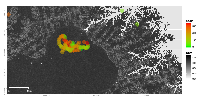
Chapter 14 is about the added value of remote sensing for animal movement analysis: tracking data (GPS/Telemetry), challenges and opportunities and basic examples of using tracking data will be covered and selected methods will be applied.
Outlook and Acknowledgements
Martin Wegmann, Benjamin Leutner and Stefan Dech